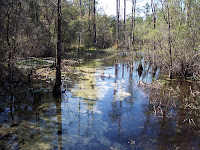

 On Sunday, April 2, 2011, The crew headed out for hike number seven. This one begins at the edge of Eglin Air Force Base about a mile south of Crestview on Hwy. 85. We began at 9:00 am on a fairly warm day for hiking. At 0.8 miles we cross Pearl Creek on a well-made bridge.
 In another tenth of a mile we come to a short side trail leading to the Pearl Creek Compsite - a rudimentary site. At 2.0 miles we cross Moore Creek on another Bridge. It seems we will see lots of water on today's hike.

The trail is well-mark and is as heavily traveled as any we've been on so far. We cross Silver Creek at 3.8 miles. At 5.7 miles we cross Honey Creek on another nice bridge complete with a park bench to sit on in the middle of the woods.

 At about the halfway point of today's hike we arrive at Jr. Walton Pond and the Jr. Walton Pond campsite. This is a pleasant location and we all stop for a snack before beginning the second half of the trek. Sherpa has brought his little dog with him and the pup has held up well. He only needed to be carried for a couple of miles. This is not to be the way it is on the second half as the fellow only lasts about a mile before coming to a dead halt at the base of a small hill and refusing to walk another step. If Sherpa's pack were larger, I'd probably do the same thing - certainly the extra weight wouldn't be noticed.
 After following a dirt road a short way we turn back into the forest crossing Titi Creek Bridge at 8.1 miles. At 10 miles we cross Big Fork Creek after walking through a particularly striking area of pines and oaks.
 Nearing the end of the hike we cross Dog Creek at 13 miles and Gum Creek at 13.6 miles. It is in this area that the trail reverses on itself for a ways to head back to the Northwest before turning back towards the east. we probably hike an extra 3/4 of a mile to make this roundabout.

At 15.5 miles we emerge from the woods onto an old section of Hwy 285 that runs alongside the current section. we have once again averaged better than 3 miles an hour and finish the hike at about 2:00 in the afternoon.
No comments:
Post a Comment